|
|
|
|
|
Moonzie Parish
The Parish of Moonzie has always been small, indeed it might have been the smallest parish in Scotland before it dissolved in 1972. The total area is about 1375 acres, and its altitude is never less than 200 feet above sea-level, rising to the church at 453 feet which makes clear the old rhyme;
Gae ye east, or gae ye west,
Or gae ye ony wey ye will,
Ye winna get tae Moonzie Kirk
Unless yae gae up Moonzie Hill.
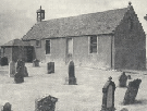
This church in Moonzie is a conspicuous object against the skyline, visible from most parts of the parish and from a wide area beyond. This fact caused the church in Moonzie to be known throughout the ages as the " Visible Kirk."
The parish records make it clear that the present building was standing prior to 1693, and it was, even then, considered to be of great age. In fact, the earliest reference to an ecclesiastical building in Moonzie appears as early as 1176. Of course, many renovations and alterations have taken place during the long history of the building.
The full history of Moonzie abounds in stirring tales of gallantry and loyalty, but it abounds too
in tales of darker deeds, for, even when the first church was there in 1202, Moonzie was already old and had seen some seven centuries of history roll over its gentle slopes, and the little church on the hilltop has watched the rise and fall of many a noble family; has watched the tide of war roll back and forth over the Kingdom of Fife and over the entire land. And in those wars the folks of Moonzie have never been slow to play their part. The Military Medal and the Victoria Cross, two of Britain's highest honours for bravery, have been awarded to men from the Parish of Moonzie.
The following is from A descriptive & historic gazeteer of the counties of Fife, Kinross & Clackmannan, M Barbieri, published in 1857.
" Moonzie is bounded on the north by Kilmany and Creich; on the south by Monimail; on the east by Cupar and Kilmany; and on the west by Creich. Length from north to south is 2 miles by 1.5 in breadth. Area 1375 acres; the whole is arable with the exception of 1.5 acres under wood and 30 acres of moss-land. The surface is finely diversified by various round-shaped hills of no great eminence, presenting in other places, particularly where it marches with Kilmany, level flats of considerable extent. Besides smaller streams, it is watered by Moonzie Burn, that rises from Lordscairnie Myre, runs east through several parishes, and falls into the Eden, near the Inner Bridge. Till within the last 60 years there was a lake or myre in the farm of Lordscairnie but by an expensive drainage it has been converted into arable ground.
This parish is the most remarkable in the county for its deficiency of trees, and, till lately, the total absence of hedges. The soil is generally a strong black loam, or a light dry loam, resting on rotten whinstone. The rent of the land may be averaged at £2-10s per acre. If this parish be not picturesque, it is one of the best agricultural ones in the county; the Fifeshire black horned cattle is preferred; much attention is bestowed on rearing good horses; there are 4 thrashing mills. Coal has to be brought from Balbirnie or Dysart; or English coal from Newburgh or Balmerino. Whinstone is found, but neither freestone nor limestone. Parish church and parish school. There has been no public house in the parish for many years.
There is neither village nor hamlet in the parish; though several small collections of houses form the residences of the agricultural labourers belonging to the different farms. The parish church situated on rising ground in the south west of the parish is 3 miles distant from Cupar, which is the nearest market town and post town."
Home Page
|
|
|
|
|
|
 |
|
